
Mayan Ruin Tours From San Pedro Belize
Guide to Mayan ruin tours from San Pedro Belize. Belize adventure tour company offering private Mayan ruin tours from San Pedro Belize. All of our Mayan ruins tours are family friendly and can be done by most age groups.
Altun Ha Tours From San Pedro

Altun Ha lies on the north-central coastal plain of Belize, in a dry tropical zone. The site was very swampy during its pre-Columbian occupation, with very few recognizable water sources. Currently, the only recognizable natural water source is a creek beyond the northern limit of the mapped area. The water sources used during occupation were Gordon Pond, which is the main reservoir, and the Camp Aguada, which is located in the site center. The site may have contained two chultuns, but provenience is lost since they are used in modern times.
The site itself consists of a central precinct composed of Groups A and B. Groups A and B and Zones C, D, and E consist of the nucleated area, with Zones G, J, K, M, N making part of the suburban area. The site does not contain any stela, suggesting that stelae were not part of ceremonial procedures. There are two recorded causeways, one in Zone C and one connecting Zone E and Zone F. The Zone C causeway does not connect to any structures, but is probably related to Structure C13, and was perhaps used for ceremonial purposes. The other causeway connected the two zones where water sources were located, and was constructed for topographical reasons, specifically to traverse areas of swampy land; it may have been impassable without raised walkways.
Altun Ha tours can be combined with cave tubing, zipline, Belize zoo, jungle atv, baboon sanctuary, horseback riding, and Belize City tour.
Cahal Pech Mayan Ruins
Cahal Pech is a Maya site located near the town of San Ignacio in the Cayo District of Belize. The site was a palatial, hilltop home for an elite Maya family, and through the most major construction dates to the Classic period, evidence of continuous habitation has been dated to as far back as 1200 BCE during the Early Middle Formative period (Early Middle Preclassic), making Cahal Pech one of the oldest recognizably Maya sites in Western Belize.
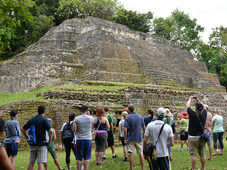
The Cahal Pech Mayan Ruin rests high above the banks of the Macal River and is strategically located to overlook the confluence of the Macal River and the Mopan River. The site is a collection of 34 structures, with the tallest temple being about 25 meters in height, situated around a central acropolis. The site was abandoned in the 9th century CE for unknown reasons.
The earliest pottery in western Belize is found here.
"Emerging information from western Belize suggests that ceramic-using populations may have been in place as early as ca. 1200 B.C. at Cahal Pech and perhaps elsewhere (Awe 1992; Clark and Cheetham 2002; Garber et al. 2004; Healy and Awe 1995). While these complexes, termed "Cunil" at Cahal Pech and "Kanocha" at Blackman Eddy, remain to be broadly documented across the Belize River Valley, they are the earliest established ceramic technologies recorded in western Belize."
The name Cahal Pech, meaning "Place of the Ticks" in the Yucatec Maya language, was given when the area was used as pasture during the first archaeological studies in the 1950s, led by Linton Satterthwaite from the University of Pennsylvania Museum. It is now an archaeological reserve, and houses a small museum with artifacts from various ongoing excavations.
The primary excavation of the site began in 1988. Restoration was completed in 2000 under the leadership of Dr. Jaime Awe, Director of the National Institute of Archaeology (NICH), Belize.
Lamanai Mayan Ruins Tours From San Pedro
Visiting Lamanai is going on three adventures in one tour. Your Lamanai Mayan Ruins Tour begins in Belize City where you will be picked up at your hotel. If you are coming from San Pedro, Ambergris Caye, or Caye Caulker, you will be picked up at the water taxi in Belize City or The Belize City Airport.
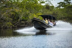
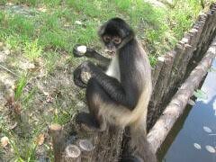
We will drive you through Belize City on to the Northern Highway where you get to see the countryside and learn about the culture of Northern Belize. Your guide will be pointing out important monuments and landmarks as we head towards the New River. You will arrive in Orange Walk Town also known locally as “Sugar City”, where you will board our boat that begins the wild life adventure up the New River. Your guides will highlight the wild life of the New River such as the spider monkeys, crocodiles, the variety of birds, and the flora and fauna along the New River banks.
On arrival at Lamanai situated off the New River Lagoon, you will be treated to a delicious Belizean buffet-style lunch of Rice & Beans, potato salad, coleslaw and fry plantain. Be sure to try out our spicy “hot” tomato habanero sauce. You’ll have a choice of an ice-cold soda or water, and the meal includes tropical fruits for dessert. After lunch, we make a start hiking to the temples of Lamanai and while on the path we’ll be looking out for the Howler monkeys and the colorful Toucans that are predominant in the area. As we arrive at the Lamanai Mayan ruins you will get to look at the Mask Temple, the High Temple, the Ball Court, the residential area and the Jaguar Temple. Your guide will give you detailed information on the historic significance of each area, and you will get the opportunity to climb up the High Temple via the original stairway built by the Mayas, and get a spectacular panoramic view of the lagoon and the surrounding jungle.
2 persons: $145.00 per person
4 persons+: $100.00 per person
Xunantunich Tours From San Pedro
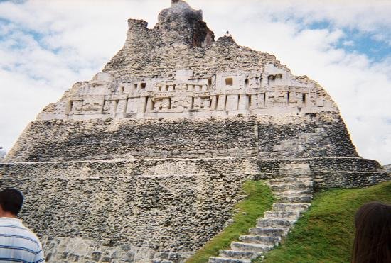
Xunantunich Mayan Ruins Belize is an Ancient Maya archaeological site in western Belize, about 70 miles (110 km) west of Belize City, in the Cayo District. Xunantunich is located atop a ridge above the Mopan River, well within sight of the Guatemala border – which is a mere 0.6 miles (1 km) to the west. It served as a Maya civic ceremonial center in the Late and Terminal Classic periods to the Belize Valley region. At this time, when the region was at its peak, nearly 200,000 people lived in Belize.
Xunantunich’s name means "Sculpture of Lady" in the Maya language (Mopan and Yucatec combination name Xunaan(Noble lady) Tuunich (stone for sculpture)), and, like many names given to Maya archaeological sites, is a modern name; the ancient name is currently unknown. The "Stone Woman" refers to the ghost of a woman claimed by several people to inhabit the site, beginning in 1892. She is dressed completely in white, and has fire-red glowing eyes. She generally appears in front of "El Castillo", ascends the stone stairs, and disappears into a stone wall.
The first modern explorations of the site were conducted by Thomas Gann in the mid-1890s. Gann moved from Britain and served as the district surgeon and district commissioner of Cayo, British Honduras, starting in 1892. He chose this area to settle in because he had an interest in Mayan archaeology, and he wished to be able to explore the (at the time) unknown wonders of the indigenous people. Gann’s successor, Sir J. Eric S. Thompson, implemented a more methodical approach, and was able to establish the region’s first ceramic chronology. The main recent archaeological teams to work at Xunantunich and the surrounding region are the Xunantunich Archaeological Project (XAP) and the Xunantunich Settlement Survey (XSS).
In 1959-60, the Cambridge Expedition to British Honduras arrived in the colony and its archaeologist member, Euan MacKie, carried out several months of excavation at Xunantunich. He excavated the upper building on Structure A-11 in Group B and a newly discovered residential structure, A-15, just outside the main complex. Using the European method of detailed recording of the stratigraphy of the superficial deposits (the masonry structures themselves were not extensively cut into) he was able to infer that both buildings had been shattered by a sudden disaster which marked the end of the Classic period occupation. An earthquake was tentatively proposed as the cause; it is inferred purely on the basis of the excavated evidence, and also on the very damaged state of the top building of Structure A-6 ('El Castillo'). He was also able to confirm the later part of the pottery sequence constructed by Thompson. The detailed report by MacKie is "Excavations at Xunantunich and Pomona, Belize, in 1959-60". British Archaeological Reports (Int. series), 251, 1985: Oxford.
Farmers that fed the people living in Xunantunich typically lived in small villages, divided into kin-based residential groups. The farms were spread out widely over the landscape, though the center of Xunantunich itself is rather small in comparison. These villages were economically self-sufficient, which may be the reason why Xunantunich lasted as long as they did; they were not dependent on the city to provide for them. Settlement density was relative to soil quality, proximity to rivers, and localized political histories. Since the farmers were long established on their plots of land, they would not want to be involved with a polity that was under constant upheaval due to invading forces and more. Other nearby Maya archaeological sites include Chaa Creek and Cahal Pech, Buenavista del Cayo, and Naranjo.
Xunantunich Mayan ruins can be combined with cave tubing, zipline, Belize zoo, Jungle atv, and horseback riding to create a full day of fun activities.
Please note that prices of our tours may vary depending on the number of persons booking. This is because we offer strictly private tours.